Memories of hiking up the Gehrenspitze: a perfect day out in the Tyrolean mountains.
After a relatively mild autumn, winter has arrived in Vienna. The November fog which usually descends for four or five days each year has now been in situ for almost three weeks, making the days darker, more dreary and depressing everyone’s mood.
In such times, I find it useful to recall memories from warmer, lighter times of year to provide some cheer.
Today, I searched out the photos of the best hike we ever did. It was two years ago in Tyrol, Austria — climbing a mountain close to the German border called the “Gehrenspitze”.
Klamm – Wangalm
The hike started at a carpark close to the village of Leutasch (“Loy-tasch”), close to the German border. A bus line runs from the main part of the village to the starting point, which is quite a bit further up towards the Gais valley in a satellite part of the village (Klamm).
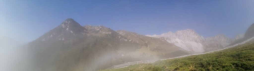
Although we had faithfully checked the weather forecast before setting off and had been assured of favourable conditions, fog was thick when we started off up the path towards the Wangalm*. The path here is easy walking — quite steep but not requiring any capabilities other than fitness and you can also follow the gravel road if you want.
Half an hour before the Wangalm, The Other Half and I get into some kind of dispute about whether to take what he thinks is a short cut through a meadow where cows may or may not be grazing. I am adamant we stick to the marked path, but he bounds off, leaving me climbing up the mountain alone, in soupy fog. I am not amused.
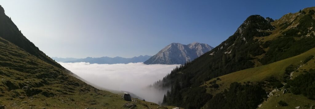
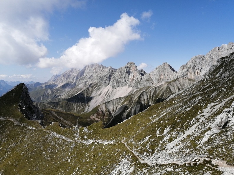
Well, it turns out his way wasn’t a short cut after all and he catches me up at the Wangalm hut where the proper path starts. I’m still chuntering about him haring off when I look up and catch the most incredible view. Straight ahead, a magnificent alpine panorama of the Wetterstein massif reveals itself as we climb out of the fog. It turns out that there is an inversion in the valley and that, above the clouds, the peaks of the mountains are bathed in brilliant sunshine. Five minutes more and we are standing free of the mist, marvelling at this heavenly vista. Our little argument is suddenly forgotten!
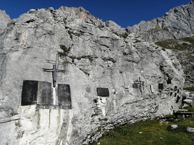
Mountaineer memorial
We stop briefly at a monument to the mountaineers who have lost their lives in this region, which is as unforgiving as it is breathtaking. The names on the monument confirm once again what I already knew — that until fairly recently, mountaineering was a largely male pursuit. Although we will see equals numbers of men and women on the mountain today, I still feel like every female footprint left behind here is an important step towards equality.
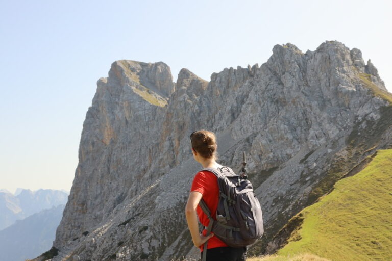
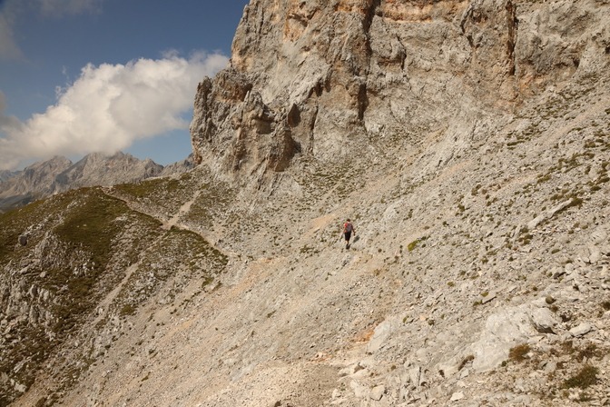
Climbing further, we reach a saddle, where we gain a view of the Gehrenspitze peak for the first time. From where we’re standing, it looks quite precipitous and slightly intimidating (see main picture)!
Austrian mountain paths are categorised along the same lines as their ski pistes: blue for easy-peasy, red for routes requiring fitness and surefootedness but no special mountaineering skills and black for the experienced (which can mean anything from an exposed passage or two to routes needing the full kit, ropes etc.). In my experience, the grading is always reliable and, since this path is a red one — I am sure that we’ll be fine, being both fit and surefooted.
The Gehrenspitze – a mountain less dramatic than it looks
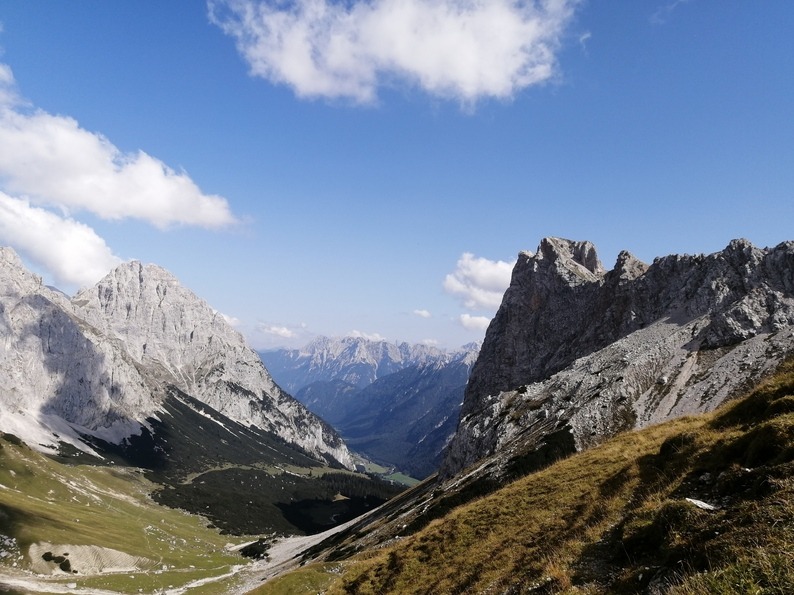
Indeed, as soon as we start off on the last leg to the summit, it becomes clear that the path is nowhere near as dramatic as it looked from further down. Most of the time, it is a narrow trail skirting the lip of the cliff to our left. There is a steep slope on our right, but no drop as such so it is absolutely safe.
The only critical passage was crossing a field of scree below a high rock face. The route was clearly marked (the Austrians are excellent at path markings) and stable underfoot — as long as you stuck to it, accident potential was low. Still, there was a risk of rock falls…in such places, it is wise not to waste any time and just get across.
At the summit of the Gehrenspitze
After 2 hours, we finally reach the summit of the Gehrenspitze and the cross of the kind which stand atop all peaks in Austria. We open the metal box affixed to it and sign the summit logbook — a lovely tradition adhered to right across the country on all mountains great and small.
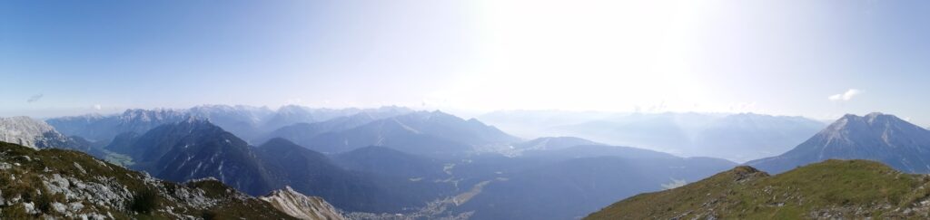
What a view! To the north, we have a commanding view of the Wetterstein massif of which the Zugspitze, Germany’s highest mountain, forms a part. The clouds have now completely dispersed and, to the south, we are gifted a majestic view across the mountainscape of Tyrol. I am not a religious person in any way, but at such moments one is suffused with a deep, almost spiritual respect for nature and a feeling of being part of something much greater and more powerful. It is very humbling.
The end of our best hike ever
The path down into the valley takes us down a steep mountain trail parallel to a rushing stream and several noisy waterfalls. With loose rocks underfoot, it’s crucial to watch where you put your feet and walking poles are an enormous help — both in terms of balance and taking the stress off your joints.
I take a small but scary tumble when the stones slip out from under me. I’m not seriously hurt (I’ll just have a huge, unsightly bruise on my right shin for a week afterwards) but it’s a reminder not to let your concentration let up for a second, even when tired. The mountains are always the more powerful party in this equation and will wipe the foolhardy off their slopes without a hint of sentimentality.
In the evening, we eat on the terrace of a local restaurant with a view of the mountain we conquered earlier. It’s a thoroughly impressive sight. With the happy and heavy tiredness of mountainclimbers weighing on us and a sizeable calorie deficit prickling our stomachs, we sit back and revel in the memories of an unforgettable day out.
[*An “alm” is an alpine meadow where you will frequently find a hut providing food, drink and basic accommodation…not to mention various animals grazing.]
—–
Related articles:
My Via Claudia Augusta adventure – cycling solo across the Alps
The Thayatal National Park: a magical autumn hike through European history
The Hochblaser: this mountain and me were not meant to be
The Soleweg – my 2007 hiking adventure
—–
Photos with me in them: Christian Wagner © 2020
Photos without me in them: Katharine Eyre © 2020